Task:
- Determination of the tilt of the building;
- Assessment of the verticality of the building.
After analyzing the method of determining verticality, which is already used at the enterprise, it was decided to perform similar measurements, but instead of angles, immediately analyze the displacement of the face of the pyramid relative to the design axis.
Goal:
- Comparison of survey results using theodolite and drones.
Hardware and software:
- Phantom 4 RTK with a 20 MP camera;
- Pix4d folders.
Processing process:
- Formation of a 3D cloud of points;
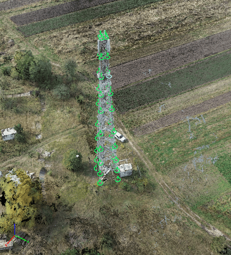
- A set of pickets according to the 3D model (Image 1).

Image 1
To increase accuracy, each point was marked on several photographs, as shown in the figure below (Image 2).

Image 2
The resulting pickets were exported to DXF for further analysis.
Given that the instructions used at the Vodafone enterprise take into account deviations along the axes of the ХУ, accordingly, the analysis of deviations was carried out in a plan where the deviations of the pickets on each tier in relation to the foundation of the object were taken into account (Image 3).

Image 3
The average values obtained were entered into the table used for roll analysis (Figure 4).

Image 4
Below is an executive diagram of deviation from drone footage based on results from the Phantom 4 RTK drone (Image 5).

Image 5
Below is a diagram obtained by the traditional method (Image 6).

Image 6
Analysis of work time:
- Field work: 30 minutes;
- Chamber works:
- Processing in automatic mode: 3 hours;
- Measurement in manual mode: 30 min.
Conclusion:
The results obtained using a drone correlate with the results obtained using a theodolite, the difference between the two types of measurements (theodolite surveying and surveying using drones) is:
- along the X axis up to 2 cm;
- along the Y axis up to 1 cm.
Advantages of using a drone:
- Good visibility of the sides of the object, as there is no distortion due to the distance from the object and deterioration of visibility on high parts of the object;
- There is no need to install the device in a special place (as in the case of the theodolite, which must be installed in the building, which is not always possible);
- Obtaining a large number of measurements during a minimum stay at the location - you can measure absolutely any point of the object;
- Photo recording of the entire object;
- The human factor is excluded, namely the direct error of aiming at the object.
Disadvantages:
- The influence of lighting on the quality of photography;
- It is necessary to study the shooting technique in advance;
- The influence of tower signals on controllability during approach is closer than 3 meters.
Recommendation:
- To check the results and for a more detailed analysis, a 3rd independent survey is required (for example, using a total station);
- Development of drone shooting techniques with the involvement of an independent party, a scientific institute.
Bonus
When processing this case, testing of drones without RTK technology was also used to assess the possibility of their application to solve this issue, namely Phantom 4 Pro, MAvic 2 Pro.
And when drawing up the verticality graphs, the deviation exceeded the allowable values by ten times, which would indicate the emergency of the building.

To check the software algorithms, this processing was performed in various software products: Pix4d mapper, Agisoft metashape, DJI Terra. And all options showed an equally unsatisfactory result.
Thus, the use of drones without RTK/RRK technology is unacceptable for assessing the verticality of structures.
On the other hand, it is an ideal and cost-effective tool for inspection and inventory, which you can read in our article at the
link .
DroneUA is an international system integrator of unmanned solutions.
On the market of Ukraine and Eastern Europe, the DroneUA group of companies is the largest importer and distributor of leading drone manufacturers in the world and presents technological solutions from the brands XAG, EcoFlow, Pix4D, Parrot, Chasing, DroneDeploy, AgroCares and others.
The group of companies has its own engineering, production and service divisions, as well as an open data processing center. Technological solutions presented by DroneUA are used on more than 4 million hectares of cultivated areas of Ukraine. According to the results of the 2021 agricultural season alone, more than 1 million hectares were treated with drone sprayers from DroneUA.
DroneUA is included in the TOP 3 most innovative businesses in the agricultural sector of Ukraine according to FORBES and the TOP 20 most innovative enterprises of Ukraine.
The group of companies continues to expand the list of technological brands that it presents on the Ukrainian market, and is active in agriculture, the oil and gas industry, as well as in the fields of energy, geodesy and topography.
Vodafone Ukraine is a leading Ukrainian telecommunications company that provides 3G and 4G high-speed Internet services. Today, the 4G network covers more than 81% of the country's territory. Vodafone serves 19 million subscribers in Ukraine.


