The data obtained with the help of aerial photography allow you to create a detailed passport of any territory or farm and obtain statistical information about all available objects.
The basis of the service is the collection and systematization of digital information:
- contours of fields, roads, buildings, reservoirs, trees, and all other objects of the economy and their classification;
- statistical information about all objects of the farm: area, percentage of the total area, quantity, calculation of distances;
- relief analysis, slope steepness, hydrological analysis;
- information on agricultural fields: fertility maps, crop rotation, potential, vegetation analysis;
- analysis of trees: number, area, height, crown diameter.
In this case, data collection was carried out by aircraft from a large area in Australia, and data generation in the orthophoto was carried out by another company.
Peculiarities of work outside Ukraine
Shooting outside Ukraine is carried out by the customer independently, if necessary, with the provision of a technical task for shooting with the indication of recommended parameters or already formed routes for drones. Next, droneUA is sent pictures for stitching in the Pix4DMapper software, or as in this case, they provide ready-made orthophoto plans.
Map analysis and creation of a digital farm passport
In this case, the input data was an orthophoto plan with a GSD of 10 cm/pixel and approximate boundaries of the farm. Contours are refined by analyzing the actual boundaries visible on the orthophoto. All data is created in GIS software, for example, QGIS.
The following maps were created with the use of GIS software based on the analysis of an orthophoto plan and a digital terrain model: a map of vegetation vegetation, a map of land use, a map of exposure and steepness of slopes, which together formed a digital passport of the farm. This set of cards can be changed and supplemented depending on the client's needs.
The technical task was agreed in detail with the customer - what classes of objects should be on the land use map, what maps should be created, and in what form the statistics will be displayed. Each project is developed specifically for the client in order to satisfy all incoming requests.

Vegetation map
Growth indicators for trees were determined on the vegetation map: number, area, height and their classification by stages of development.
Counting of trees and determination of crown height and area was created on the basis of digital surface model (DSM) analysis and vegetation indices extracted from Red Green Blue maps.

Exposure map
Maps with determination of exposure (spatial orientation) of slopes were created automatically using QGIS tools. Exposure depends on the intensity of sunlight on the landscape, which forms the microclimate of the area, the type of soil, determines the types of plants that will grow in a specific area, etc.

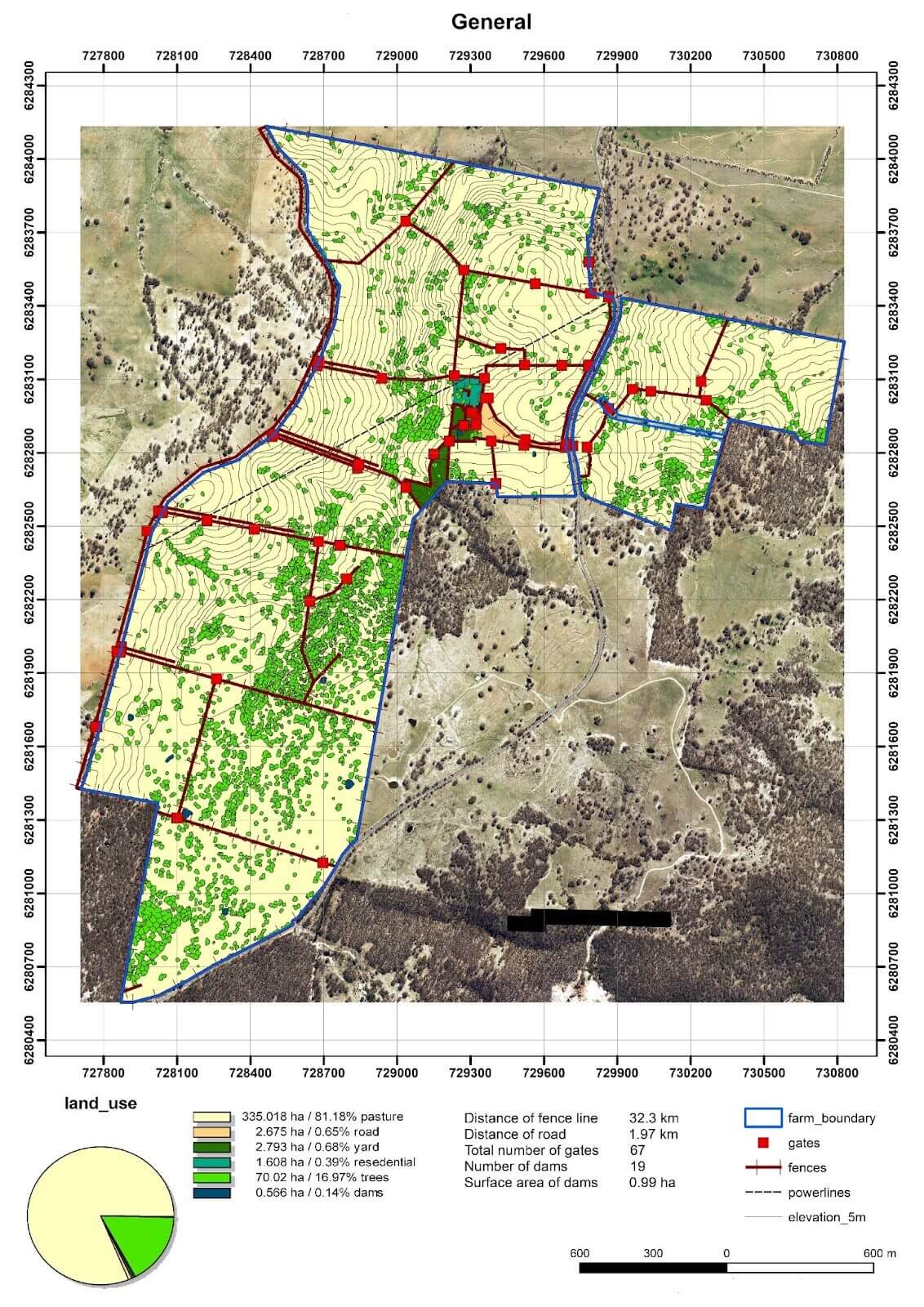
General map
General map of the farm with classification of objects and statistical data about each of them.

Slope steepness map
The analysis of the steepness of the slopes allows you to determine the places available for the passage of equipment, and can be used for design work on the construction of roads, or the planning of fruit plantations.
Advantages of a digital passport:
- all information is available on a computer and smartphone, it is possible to manipulate spatial data: overlay different layers on top of each other, highlight the necessary data; add information to digital circuits in the area;
- accurate detailed statistics: total/cultivated land area, distance between objects, their size and number, etc.;
- assessment and comparison of the potential of fields taking into account the relief;
- optimization of processes, creation of maps for planters and sprayers;
- the possibility of integration into electronic systems used by the economy.
Results:
- maps of farm objects and analytics in geoTIFF, SHP and KMZ formats;
- statistics on fields and other objects in the form of reports and tables;
- interactive web maps with statistics in the form of an HTML file that can be opened in any browser and can also be downloaded to your own host. It is also possible to create a client's office on our Spatiolab GIS platform , where all the data of the digital passport of the territory or farm will be displayed.
DroneUA is an international system integrator of unmanned solutions.
On the market of Ukraine and Eastern Europe, the DroneUA group of companies is the largest importer and distributor of leading drone manufacturers in the world and presents technological solutions from the brands XAG, EcoFlow, Pix4D, Parrot, Chasing, DroneDeploy, AgroCares and others.
The group of companies has its own engineering, production and service divisions, as well as an open data processing center. Technological solutions presented by DroneUA are used on more than 4 million hectares of cultivated areas of Ukraine. According to the results of the 2021 agricultural season alone, more than 1 million hectares were treated with drone sprayers from DroneUA.
DroneUA is among the top three most innovative businesses in the agricultural sector of Ukraine according to FORBES and among the twenty most innovative enterprises of Ukraine.
The group of companies continues to expand the list of technological brands that it presents on the Ukrainian market, and is active in agriculture, the oil and gas industry, as well as in the fields of energy, geodesy and topography.


