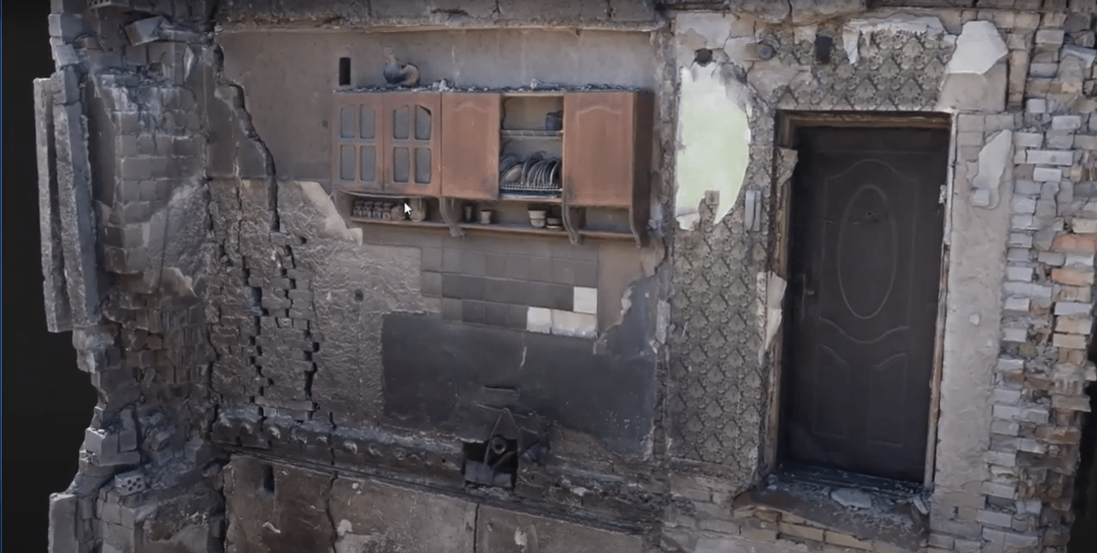
3D model of a kitchen cabinet and a ceramic rooster for museumization of a historical monument

In April 2022, after the de-occupation of Ukrainian cities in the Kyiv region, the task of journalists and photographers was to record the consequences of Russian aggression in order to inform the whole world about it and preserve it in national memory. Just then, in one of the photos in the city of Borodyanka, a kitchen cupboard that survived the bombing appeared. Together with all the utensils and the ceramic rooster on top, it survived and became one of the symbols of resistance in this war.
It was decided to transfer the legendary locker and rooster to the National Museum of the Revolution of Dignity • Maidan Museum. But the building was already in a state of disrepair, and the process of museification rather turned into a "special operation".

Task. In order to reproduce the monument as accurately as possible, it was necessary to correctly collect the necessary material. Namely, record all the information in as much detail as possible, even down to the screws holding the locker. It was also important to get a general picture: the surrounding area, destroyed buildings and a wall with a locker that survived. At the end, you should get a 3D model of the surface (3D Mesh), which you can rotate and look at every detail.

Process. The DroneUA team joined the expedition of the Heritage Rescue Headquarters together with the cultural institution "Mizhvukhamy" , PrJSC "System Solutions" JSC System Solutions and the State Emergency Service of Ukraine . With the assistance of the Borodyan settlement united territorial community and the Ministry of Culture and Information Policy of Ukraine .
Although there are many ways to create 3D models in the world, for photofixation and further reconstruction and preservation of the monument, we chose the most popular method - photogrammetric. It is proven on many projects in construction, creation of digital accounts, replicas, etc.
The essence of the method is to take a number of photos of the object from different angles so that each point is included in at least 6 pictures. Thousands of such points will form a surface - the ground, a house or an object. Based on this data, the program will simulate the position of the structure in space and we will get a 3D Mesh.
The model was built using special photogrammetric programs (such as Pix4D RealityCapture, ContexCapture) and appropriate cloud processing. Such processing usually takes 1-2 days, as it is necessary to choose the optimal parameters between the capabilities of the PC and maximum detail.
For what other tasks is the photogrammetric method used? The method is very popular, DroneUA already has a number of cases of its use. It is most often used in geodesy, agro, gaming, construction, control surveying.
In wartime, it was already used to record primary infrastructure damage and preserve information about other cultural monuments.
Filming with a drone is an opportunity to reproduce an accurate 3D model of the territory, building or other objects. It is to capture every detail in order to preserve historical memory on digital media.
From the DroneUA team, the following worked on the case: drone operator Serhiy Andrushenko , who took photos, and GIS specialist Hleb Lisovy , who created a 3D model using software.
DroneUA is an international system integrator of unmanned solutions.
On the market of Ukraine and Eastern Europe, the DroneUA group of companies is the largest importer and distributor of leading drone manufacturers in the world and presents technological solutions from the brands XAG, EcoFlow, Pix4D, Parrot, Chasing, DroneDeploy, AgroCares and others.
The group of companies has its own engineering, production and service divisions, as well as an open data processing center. Technological solutions presented by DroneUA are used on more than 4 million hectares of cultivated areas of Ukraine. According to the results of the 2021 agricultural season alone, more than 1 million hectares were treated with drone sprayers from DroneUA.
DroneUA is among the top three most innovative businesses in the agricultural sector of Ukraine according to FORBES and among the twenty most innovative enterprises of Ukraine.
The group of companies continues to expand the list of technological brands that it presents on the Ukrainian market, and is active in agriculture, the oil and gas industry, as well as in the fields of energy, geodesy and topography.


